TechnicalGIS Environmental News Desk
Budhi Gandaki disaster: satellites map candidate landslide areas in Gorkha
Revision 2 · Published 2026-11-13T12:58:24Z · Landslide · Budhi Gandaki valley, Gorkha District, Nepal
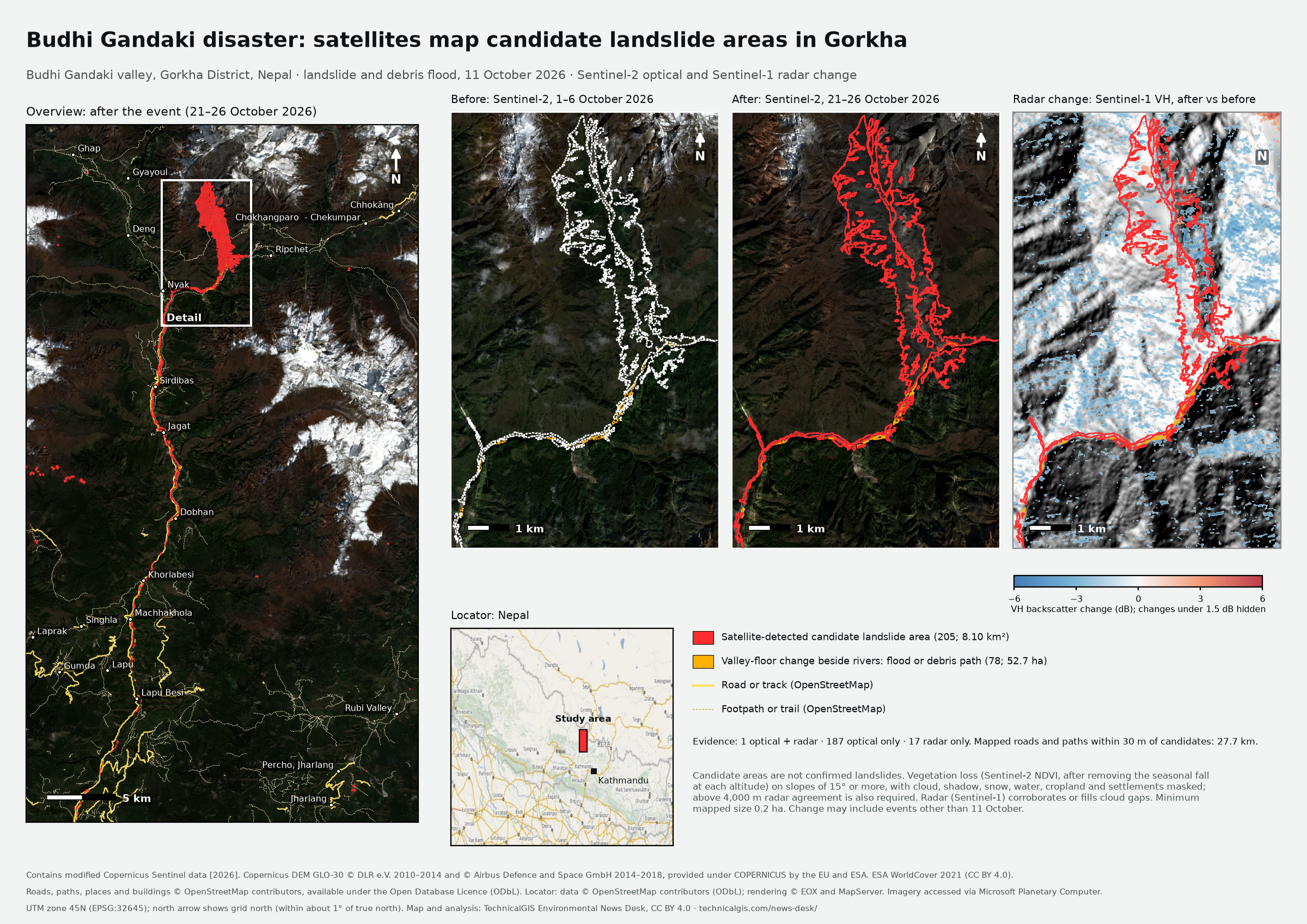
Map meaning: Satellite-detected candidate landslide areas are surfaces where vegetation was lost or radar backscatter changed between the before and after images. They are not confirmed landslides and have not been checked on the ground.
What happened
In the early hours of 11 October 2026, a mass of rock, ice and debris came down the Ungdilung Khola above Chumchet in Chumnubri Rural Municipality, Gorkha. It blocked the Syar Khola and sent a series of mud-laden surges down the Syar and Budhi Gandaki rivers. Nepal's Department of Mines and Geology timed the landslide at about 04:20 local time. It estimated the largest surge at 20–25 m high when it hit the Budhi Gandaki hydropower camp at Salleri at about 06:30. At Arughat, the river gauge passed its 5 m danger level at 07:50 and peaked at 8.43 m at 08:40. The exact mechanism is still being discussed. Early reports described a landslide dam on the Syar Khola that burst. The Department of Mines and Geology describes a high-altitude avalanche and landslide whose debris briefly ponded the Syar Khola. Landslide researcher Dave Petley reads post-event Sentinel-2 imagery as a rock-slope failure that turned into a rock avalanche and debris flow, without a dam collapse. Rain was not the trigger.
Reported impacts
- People missing: 5 (herders at a shed on the Ungdilung Khola, Chumnubri-6); no deaths confirmed (official, as reported on 12–13 October; Nepal Red Cross listed 6 out of contact on 29 October). Kathmandu Post, citing Gorkha District Administration Office and police; NDRRMA situation report via Nepal News, 12–13 October 2026.
- People rescued by helicopter: 95 on the first day; 1,044 between 11 and 15 October, including 70 foreign nationals (official). NDRRMA situation report via Nepal News (12 October); Gorkha Assistant Chief District Officer via Nepal News (15 October), 12 and 15 October 2026.
- Houses damaged or destroyed: about 204 across Chumnubri, Dharche, Arughat (Gorkha) and Tripurasundari (Dhading) (provisional; the split between destroyed and damaged was not confirmed). NDRRMA situation report via Nepal News, 12 October 2026.
- Households affected: more than 550 (provisional; Nepal Red Cross counted 146 on 29 October, probably with a different scope). WFP, citing NDRRMA, 13 October 2026.
- Bridges: 2 motorable and 2 suspension bridges lost, including the Arughat bridge linking Gorkha and Dhading (provisional; later Nepal Red Cross figures are higher (2 permanent, 1 Bailey and 6 suspension)). WFP, citing NDRRMA; Nepal Red Cross Bulletin 04, 13 and 29 October 2026.
- Hydropower: 3 projects under construction damaged; the 341 MW Budhi Gandaki project camp at Salleri was swept away (official). NDRRMA situation report via Nepal News; Department of Mines and Geology report via Telangana Today/IANS, 12?14 October 2026.
What the satellites show
- Candidate landslide areas
- 205 covering about 8.10 km² (1 optical and radar, 187 optical only, 17 radar only)
- Valley-floor change beside rivers
- 78 areas, about 52.7 ha
- Mapped roads and paths within 30 m of candidates
- about 27.7 km
- Imagery compared
- Sentinel-2 1–6 October 2026 and 21–26 October 2026; Sentinel-1 radar, two orbit directions
- Area calculation
- Candidate area is the planimetric area of the 10 m UTM 45N pixels in each polygon; it is not corrected for slope.
Sources and licences
- Copernicus Sentinel-2 Level-2A surface reflectance — Copernicus Sentinel data terms (free, full and open). Contains modified Copernicus Sentinel data [2026]
- Copernicus Sentinel-1 radiometrically terrain-corrected backscatter (from GRD) — Copernicus Sentinel data terms (free, full and open); RTC processing by Microsoft Planetary Computer, CC BY 4.0. Contains modified Copernicus Sentinel data [2026]
- Copernicus DEM GLO-30 — Copernicus DEM licence (free, worldwide, with attribution). Copernicus DEM GLO-30 © DLR e.V. 2010–2014 and © Airbus Defence and Space GmbH 2014–2018, provided under COPERNICUS by the European Union and ESA
- ESA WorldCover 10 m 2021 v200 — CC BY 4.0. © ESA WorldCover project 2021 / Contains modified Copernicus Sentinel data (2021) processed by ESA WorldCover consortium
- OpenStreetMap roads, paths, buildings, places and rivers (Overpass API) — Open Database Licence (ODbL) 1.0. © OpenStreetMap contributors, available under the Open Database Licence (ODbL)
- EOX Maps WMS (OpenStreetMap locator) — OpenStreetMap data under ODbL; rendering by EOX and MapServer. Locator: data © OpenStreetMap contributors (ODbL); rendering © EOX and MapServer
Coverage
The analysis covers a 0.28° × 0.45° box around the Budhi Gandaki valley, Gorkha District, Nepal. Changes outside it, and slides smaller than the minimum mapped size, are not included.