TechnicalGIS Environmental News Desk
Cyclone Murasu: satellite map of candidate flooded areas on the Andhra Pradesh coast
Revision 1 · Published 2026-11-13T19:44:35Z · Flood (satellite analysis) · Bapatla, Guntur and Prakasam districts, Andhra Pradesh, India
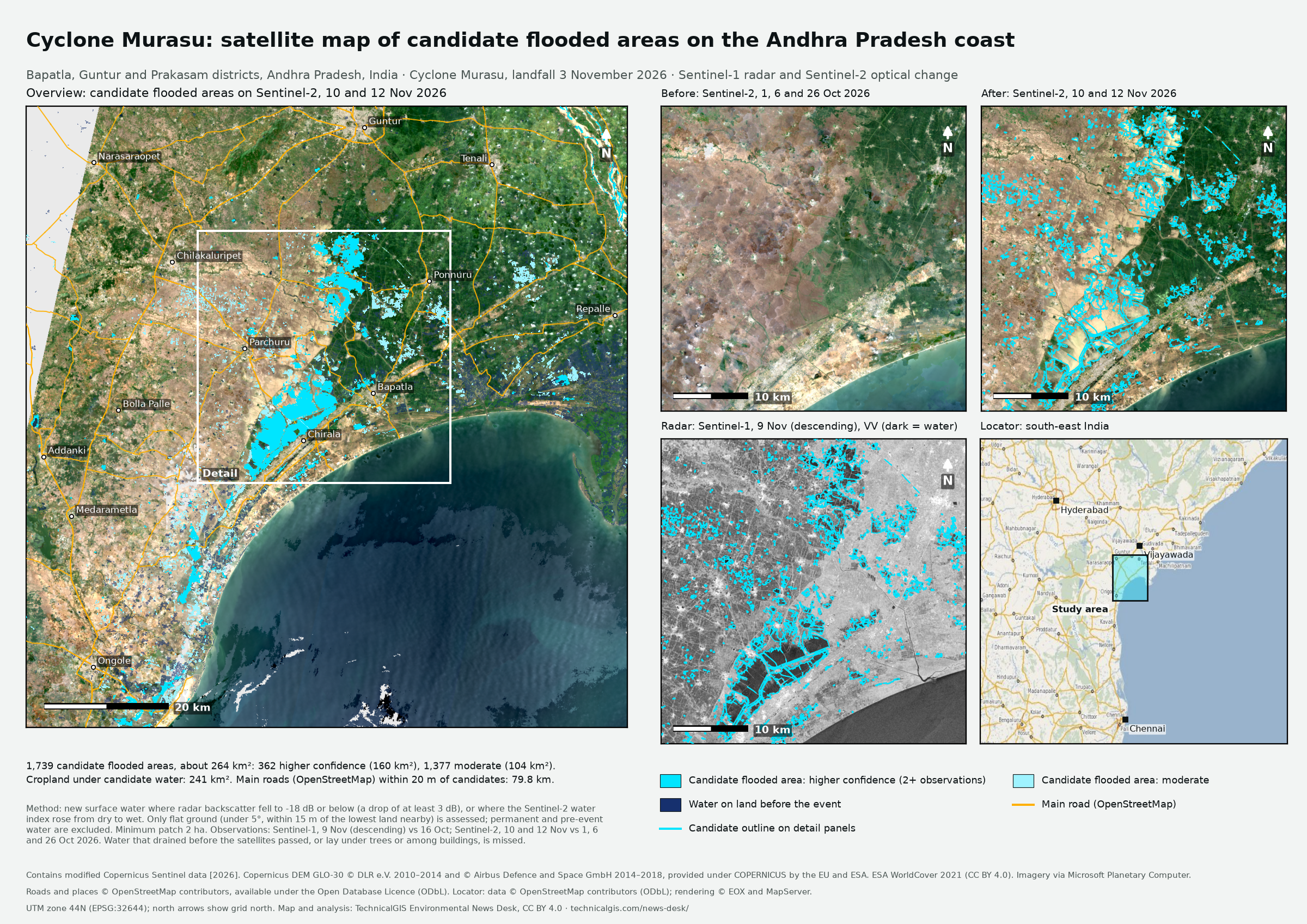
Map meaning: Satellite-detected surface water that was not there before the event. These are candidate flooded areas, not a confirmed flood extent, and they have not been checked on the ground.
What happened
Severe cyclonic storm Murasu crossed the Andhra Pradesh coast near Ongole in Prakasam district at about 1 am IST on Tuesday 3 November 2026, according to the India Meteorological Department (IMD). The UN and EU Global Disaster Alert and Coordination System (GDACS) gave the storm its highest, Red, alert. It arrived about a week after Cyclone Arnab, which had already hit the same coast. IMD warned of flash floods in Bapatla, Guntur, Krishna, Palnadu, Prakasam and SPSR Nellore districts. In the 24 hours to 8.30 am on 3 November, IMD recorded 22 cm of rain at Bapatla, and municipal gauges recorded about 313 mm at Ponnur and 298 mm in Guntur city. On 5 November officials told Chief Minister N. Chandrababu Naidu that eight people had died: five in Bapatla district, two in Guntur and one in Palnadu.
Reported impacts
- Deaths: 8: five in Bapatla district, two in Guntur and one in Palnadu (official figures given to the Chief Minister's review). The News Minute, 5 November 2026.
- Crops: 143,122 hectares of agricultural crops damaged, affecting 186,063 farmers; 6,749 hectares of horticultural crops (preliminary; officials said a fuller assessment would follow once floodwater receded). The News Minute, 5 November 2026.
- Homes, boats and roads: 983 houses, 346 boats and 220 fishing nets damaged; 760 km of major district roads and state highways damaged (preliminary). The News Minute, 5 November 2026.
- Estimated losses: Rs 1,918.55 crore (preliminary). The News Minute, 5 November 2026.
- Heaviest rainfall: 22 cm at Bapatla in the 24 hours to 8.30 am on 3 November (IMD); 312.76 mm at Ponnur and 298.36 mm in Guntur city (municipal gauges) (as reported). Deccan Chronicle; The Times of India, 3 November 2026.
What the satellites show
- Candidate flooded areas
- 1,739 covering about 264 km² (362 higher confidence, seen by two or more observations; 1,377 moderate)
- Cropland under candidate water
- about 241 km²
- Main roads within 20 m of candidate water
- about 79.8 km
- Observations
- Sentinel-1, 9 Nov (descending) compared with 16 Oct: 154 km² of new surface water
- Sentinel-2, 10 and 12 Nov compared with 1, 6 and 26 Oct 2026: 253 km² of new surface water
- Area calculation
- Candidate area is the planimetric area of the 20 m UTM zone 44N pixels in each polygon.
References
- GDACS (UN and European Commission), Tropical cyclone MURASU-26: Red alert, 1–3 November 2026, November 2026
- India Meteorological Department, Severe cyclonic storm Murasu: bulletin issued at 11:20 IST on 3 November 2026, 3 November 2026
- Hindustan Times, Cyclone Murasu makes landfall in Andhra Pradesh, triggers heavy rain; thousands evacuated, 3 November 2026
- The News Minute, Cyclone Murasu: 8 dead, CM Naidu estimates damages at Rs 1,919 cr in Andhra, 5 November 2026
- Deccan Chronicle, Murasu causes crop damage, flooding in south coastal AP, 3 November 2026
- The Times of India, Cyclone 'Murasu' triggers heavy rainfall, inundation in coastal AP; Guntur records 298 mm, Ponnur 313 mm, 3 November 2026
- NRSC/ISRO National Database for Emergency Management, Andhra Pradesh cyclone: water accumulated areas from RISAT-1A, 5 November 2026 18:00, 5 November 2026
- NRSC/ISRO National Database for Emergency Management, Andhra Pradesh cyclone: water accumulated areas from RCM, 6 November 2026 06:00, 6 November 2026
Coverage
The analysis covers a 0.90° × 0.90° box (79.95–80.85° E, 15.42–16.32° N) around Bapatla, Guntur and Prakasam districts, Andhra Pradesh, India. Water outside it, water that had drained before the satellites passed, and patches smaller than 2 ha are not included.