TechnicalGIS Environmental News Desk
Storm Adam: satellite map of candidate flooded areas around Oliva, Pego and Gandia
Revision 1 · Published 2026-11-13T19:44:35Z · Flood (satellite analysis) · La Safor and Marina Alta, Valencia and Alicante, Spain
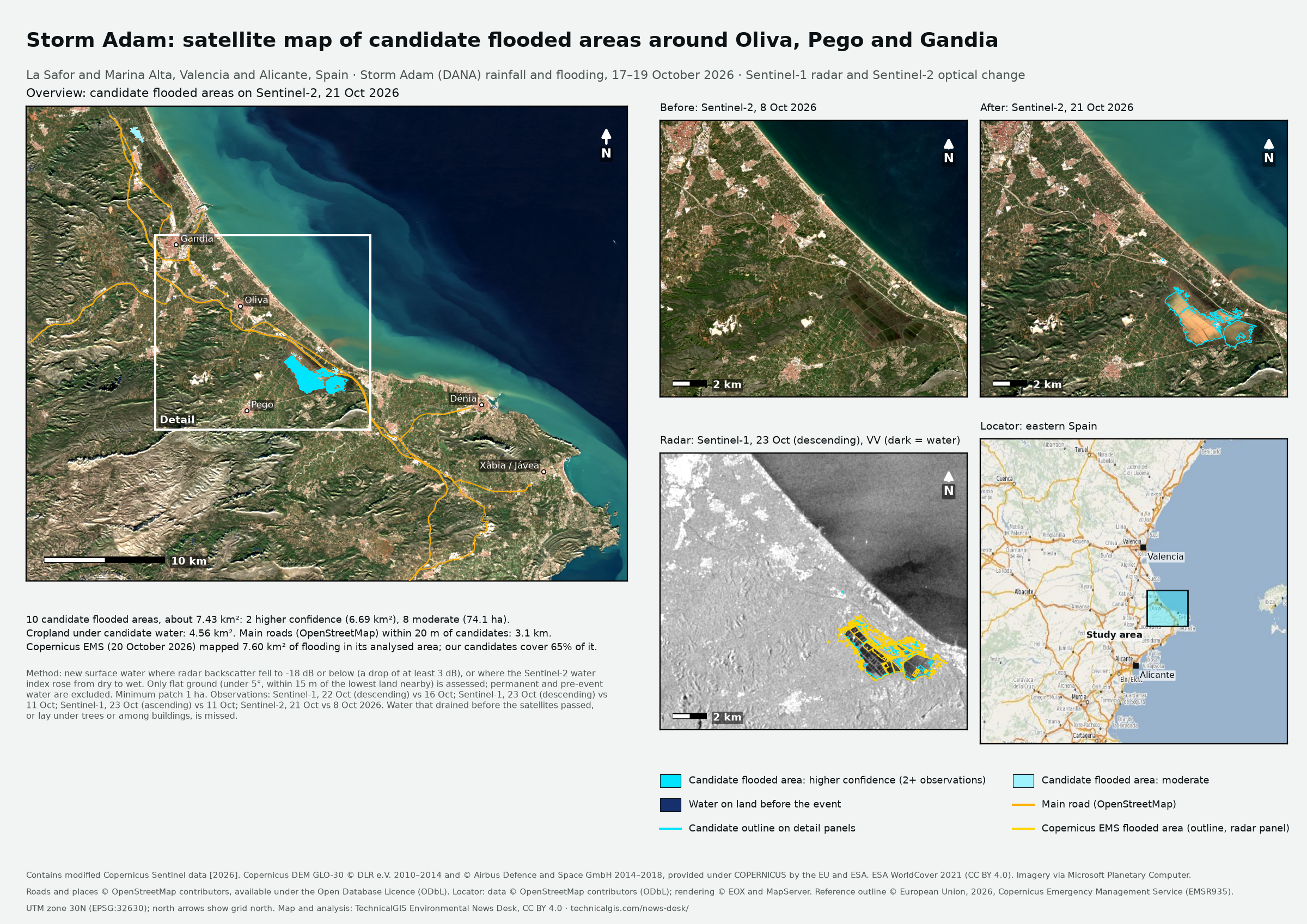
Map meaning: Satellite-detected surface water that was not there before the event. These are candidate flooded areas, not a confirmed flood extent, and they have not been checked on the ground.
What happened
Storm Adam, a cut-off low (DANA) named by Spain's state meteorological agency AEMET on 16 October, brought torrential rain to eastern Spain from 17 to 19 October 2026. The comarcas of La Safor (Valencia) and Marina Alta (Alicante) were among the hardest hit. AEMET recorded 634 litres per square metre in 24 hours at Pego, spread across 18 and 19 October, and media reports gave about 713 mm at L'Atzúbia and about 600 mm at Oliva over the episode. The Girona and Vernisa rivers and the Beniopa ravine burst their banks. On 19 October RTVE reported four deaths linked to the storm: two in Oliva, one in Sagunto and one in Cabrera de Mar, near Barcelona. The same day Spain's civil protection authority asked the Copernicus Emergency Management Service for rapid flood mapping (activation EMSR935).
Reported impacts
- Deaths: 4: two in Oliva, one in Sagunto (Valencia) and one in Cabrera de Mar (Barcelona) (as reported on 19 October; some later reports give higher totals that we could not confirm, so they are not used here). RTVE, 19 October 2026.
- Heaviest rainfall: 634 l/m² in 24 hours at Pego (AEMET); about 713 mm at L'Atzúbia and about 600 mm at Oliva over the episode (media reports) (AEMET figure official; episode totals as reported). AEMET; Euronews, October 2026.
- Rescues and evacuations: 496 rescues and 2,141 evacuations by the Guardia Civil (as reported). The Watchers, citing the Guardia Civil, 20 October 2026.
- Stay-at-home orders: residents of 145 municipalities, about 800,000 people, were told to stay at home; the order was lifted on 19 October (official, as reported). RTVE, 19 October 2026.
- Copernicus EMS mapping (EMSR935): Moraira area: 897.7 ha flooded and 210.8 ha of flood traces on 20 October; Gandia area: 129.7 ha flooded and 915 residential buildings affected (rapid mapping from very-high-resolution satellite images of 20 October; not validated in the field). Copernicus Emergency Management Service, 20 October 2026.
What the satellites show
- Candidate flooded areas
- 10 covering about 7.43 km² (2 higher confidence, seen by two or more observations; 8 moderate)
- Cropland under candidate water
- about 4.56 km²
- Main roads within 20 m of candidate water
- about 3.1 km
- Compared with Copernicus EMS
- Inside the analysed area of Copernicus EMS EMSR935, AOI01 Moraira delineation map (SPOT-6/7, 20 October 2026), our candidates cover 65% of the 7.60 km² it mapped as flooded. The later, coarser radar passes miss water that had already drained.
- Observations
- Sentinel-1, 22 Oct (descending) compared with 16 Oct: 1.11 km² of new surface water
- Sentinel-1, 23 Oct (descending) compared with 11 Oct: 2.42 km² of new surface water
- Sentinel-1, 23 Oct (ascending) compared with 11 Oct: 2.54 km² of new surface water
- Sentinel-2, 21 Oct compared with 8 Oct 2026: 7.51 km² of new surface water
- Area calculation
- Candidate area is the planimetric area of the 20 m UTM zone 30N pixels in each polygon.
References
- Copernicus Emergency Management Service, EMSR935: Flood in Alicante-Valencia Regions, Spain (activation page and products), 19–20 October 2026
- Copernicus Emergency Management Service, Flood in Alicante-Valencia Regions, Spain (EMSR935), October 2026
- AEMET, Lluvias torrenciales de octubre de 2026 (study of the DANA Adam episode), October 2026
- RTVE, DANA Adam: live coverage, Monday 19 October, 19 October 2026
- Euronews, At least five killed and thousands evacuated as Storm Adam batters eastern Spain, 20 October 2026
- The Watchers, Four deaths reported as DANA Adam flooding prompts more than 1 000 rescues in eastern Spain, 20 October 2026
Sources and licences
- Copernicus Sentinel-1 radiometrically terrain-corrected backscatter (from GRD) — Copernicus Sentinel data terms (free, full and open); RTC processing by Microsoft Planetary Computer, CC BY 4.0. Contains modified Copernicus Sentinel data [2026]
- Copernicus Sentinel-2 Level-2A surface reflectance — Copernicus Sentinel data terms (free, full and open). Contains modified Copernicus Sentinel data [2026]
- Copernicus DEM GLO-30 — Copernicus DEM licence (free, worldwide, with attribution). Copernicus DEM GLO-30 © DLR e.V. 2010–2014 and © Airbus Defence and Space GmbH 2014–2018, provided under COPERNICUS by the European Union and ESA
- ESA WorldCover 10 m 2021 v200 — CC BY 4.0. © ESA WorldCover project 2021 / Contains modified Copernicus Sentinel data (2021) processed by ESA WorldCover consortium
- OpenStreetMap main roads, places and rivers (Overpass API) — Open Database Licence (ODbL) 1.0. © OpenStreetMap contributors, available under the Open Database Licence (ODbL)
- EOX Maps WMS (OpenStreetMap locator) — OpenStreetMap data under ODbL; rendering by EOX and MapServer. Locator: data © OpenStreetMap contributors (ODbL); rendering © EOX and MapServer
- Copernicus EMS EMSR935, AOI01 Moraira delineation map (SPOT-6/7, 20 October 2026) (used for comparison only; not redistributed) — Copernicus EMS products: free use with attribution. © European Union, 2026, Copernicus Emergency Management Service (EMSR935)
Coverage
The analysis covers a 0.56° × 0.34° box (-0.32–0.24° E, 38.72–39.06° N) around La Safor and Marina Alta, Valencia and Alicante, Spain. Water outside it, water that had drained before the satellites passed, and patches smaller than 1 ha are not included.