TechnicalGIS Environmental News Desk
Cyclone Akvan: about 73,000 people live on low-lying land along the Andhra Pradesh coast
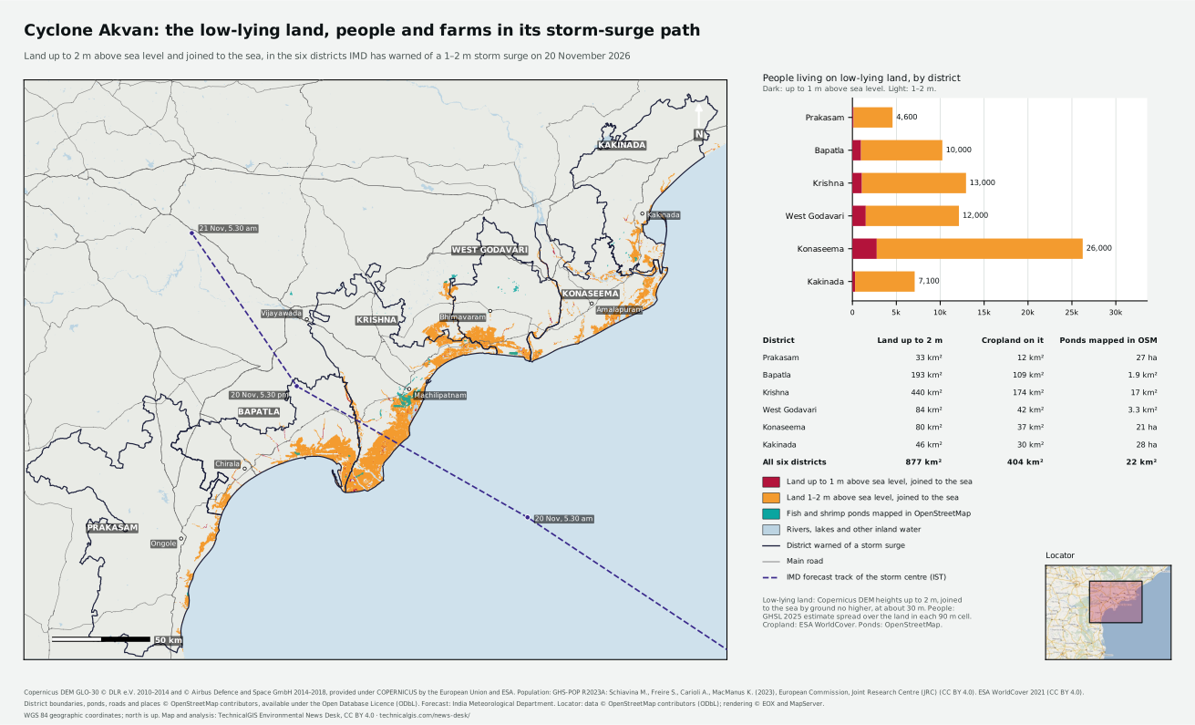
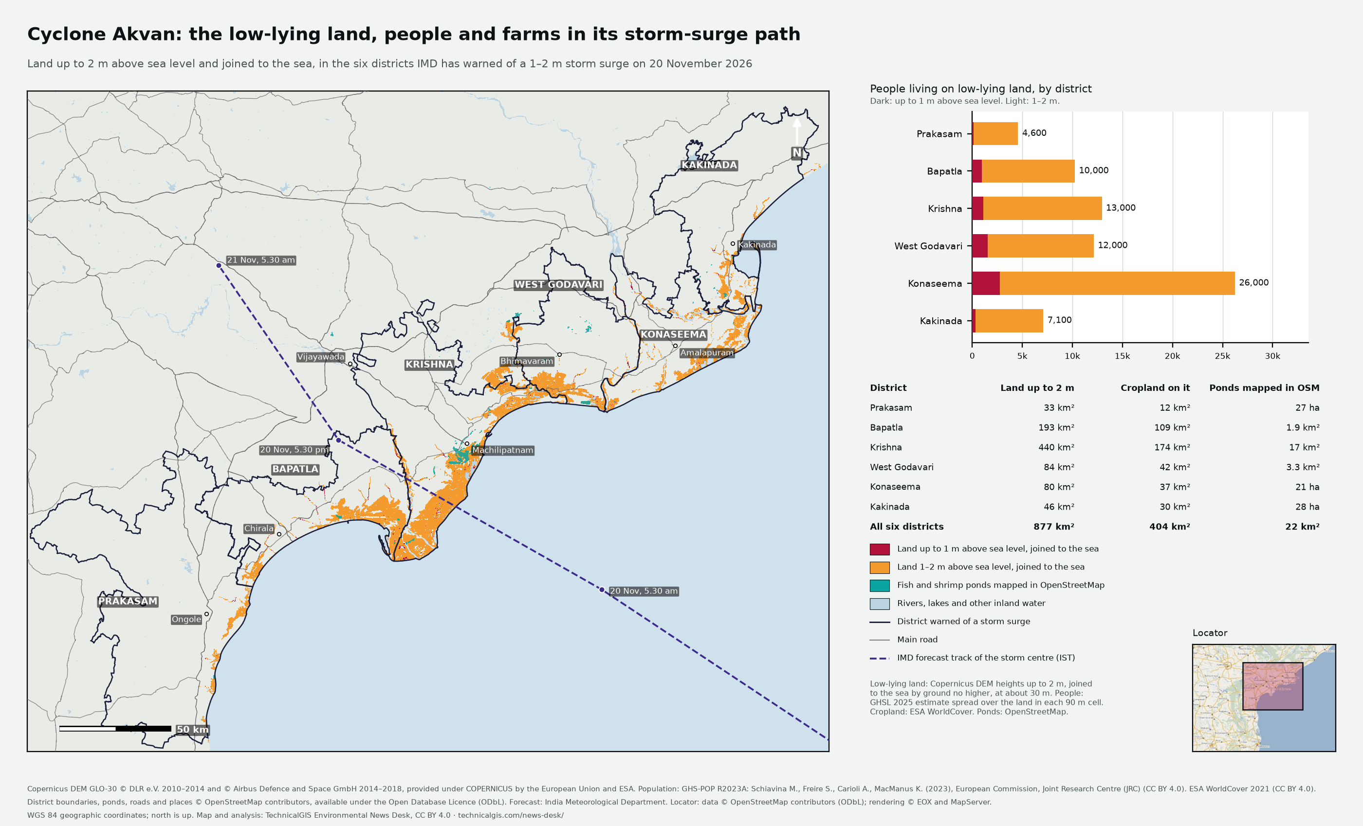
Forecasters expect a storm surge of 1–2 m in six coastal districts. Our map shows 877 square kilometres of land there no more than 2 m above the sea and open to it, including 404 square kilometres of cropland and the fish and shrimp ponds of the Krishna and Godavari deltas.
Revision 3 · Published 2026-11-17T13:41:27Z · Cyclone · Prakasam, Bapatla, Krishna, West Godavari, Konaseema and Kakinada districts, Andhra Pradesh, India
Map meaning: Low-lying land is ground up to 2 m above mean sea level, from a satellite elevation model, that is joined to the sea by ground no higher. It shows where the forecast storm surge could reach over open ground. Embankments, drains and the timing of the tide decide where the water actually goes.
What is coming
Cyclone Akvan was over the Bay of Bengal at 8.30 am IST on Tuesday 17 November 2026, about 610 km east of Chennai and 660 km south-east of Machilipatnam. The India Meteorological Department (IMD) expects it to strengthen into a severe cyclonic storm that evening and a very severe cyclonic storm by the morning of 19 November, then cross the Andhra Pradesh and Yanam coast between Nellore and Tuni around noon on 20 November, with winds of 120–130 km/h gusting to 145 km/h. IMD has warned of a storm surge of 1–2 m above the astronomical tide in Prakasam, Bapatla, Krishna, West Godavari, Konaseema and Kakinada districts, highest over Bapatla, Krishna and West Godavari from the morning to the afternoon of 20 November.
- Position at 8.30 am IST on 17 November: 12.2°N 85.7°E, about 610 km east of Chennai.
- Expected to become a severe cyclonic storm on the evening of 17 November and a very severe cyclonic storm by the morning of 19 November.
- Landfall between Nellore and Tuni around noon on 20 November, with winds of 120–130 km/h gusting to 145 km/h.
- Storm surge of 1–2 m above the astronomical tide in Prakasam, Bapatla, Krishna, West Godavari, Konaseema and Kakinada districts.
- The surge is expected to peak over Bapatla, Krishna and West Godavari from the morning to the afternoon of 20 November.
- Heavy to extremely heavy rain is forecast over coastal Andhra Pradesh on 19 and 20 November.
Forecast source: IMD Cyclone Warning Centre Visakhapatnam, press bulletin 8, 1.30 pm IST on 17 November 2026.
Who and what lies on low-lying land
Across the six districts, about 73,000 people live on 877 km² of land no more than 2 m above mean sea level that is joined to the sea. It includes 404 km² of cropland and 22 km² of fish and shrimp ponds mapped in OpenStreetMap. About 6,800 people live on land no more than 1 m above sea level.
Earlier this month Cyclone Murasu left about 264 km² of candidate floodwater on this coast. Only 7% of it lies on land up to 2 m joined to the sea: most of Murasu's flooding was rain and river water on ground that a storm surge would not reach. Read our satellite map of Murasu's flooding.
| District | Land up to 2 m | People up to 2 m | People up to 1 m | Cropland up to 2 m | Ponds mapped in OpenStreetMap, up to 2 m |
|---|
| Prakasam | 33 km² | 4,600 | 100 | 12 km² | 27 ha |
|---|
| Bapatla | 193 km² | 10,000 | 1,000 | 109 km² | 1.9 km² |
|---|
| Krishna | 440 km² | 13,000 | 1,100 | 174 km² | 17 km² |
|---|
| West Godavari | 84 km² | 12,000 | 1,500 | 42 km² | 3.3 km² |
|---|
| Dr B.R. Ambedkar Konaseema | 80 km² | 26,000 | 2,800 | 37 km² | 21 ha |
|---|
| Kakinada | 46 km² | 7,100 | 300 | 30 km² | 28 ha |
|---|
| All six districts | 877 km² | 73,000 | 6,800 | 404 km² | 22 km² |
|---|
How we made this map
- Ground height
- Copernicus DEM GLO-30, resampled to a 1 arc-second grid (about 30 m). Heights are above the EGM2008 geoid, close to mean sea level.
- Joined to the sea
- For each height (1 m and 2 m), land counts when it can be reached from the open sea over ground no higher than that height. Low hollows cut off by higher ground are left out.
- People
- GHSL 2025 population estimate (3 arc-second cells), shared across the land in each cell.
- Cropland and ponds
- Cropland from ESA WorldCover 2021. Fish and shrimp ponds are the areas OpenStreetMap volunteers have mapped; they cover only part of the ponds in the Krishna and Godavari deltas, so the real pond area is larger.
- Districts and areas
- OpenStreetMap boundaries of the districts formed in 2022. Areas are summed from 1 arc-second (about 30 m) pixels, each measured on the WGS 84 ellipsoid, inside OpenStreetMap district boundaries.
- What the map does not show
- Where water will actually go: embankments, sluices, drains and the tide decide that. The elevation model measures the tops of trees and buildings and can be a metre or more out on flat ground. Flooding from rain and rivers is not included.
Sources and licences
- Copernicus DEM GLO-30 — Copernicus DEM licence (free, worldwide, with attribution). Copernicus DEM GLO-30 © DLR e.V. 2010–2014 and © Airbus Defence and Space GmbH 2014–2018, provided under COPERNICUS by the European Union and ESA
- GHS-POP R2023A population grid, 2025 estimate, 3 arc-second — CC BY 4.0. GHS-POP R2023A: Schiavina M., Freire S., Carioli A., MacManus K. (2023), European Commission, Joint Research Centre (JRC)
- ESA WorldCover 10 m 2021 v200 — CC BY 4.0. © ESA WorldCover project 2021 / Contains modified Copernicus Sentinel data (2021) processed by ESA WorldCover consortium
- OpenStreetMap district boundaries, aquaculture ponds, main roads and towns (Overpass API) — Open Database Licence (ODbL) 1.0. © OpenStreetMap contributors, available under the Open Database Licence (ODbL)
- India Meteorological Department cyclone bulletins (forecast track and storm-surge warning) — Facts reported with attribution; bulletins not redistributed. India Meteorological Department
- EOX Maps WMS (OpenStreetMap locator) — OpenStreetMap data under ODbL; rendering by EOX and MapServer. Locator: data © OpenStreetMap contributors (ODbL); rendering © EOX and MapServer
Coverage
The analysis covers the six districts named in the IMD storm-surge warning, inside a box from 79.30° to 82.65° E and 14.95° to 17.60° N. Low-lying land in neighbouring districts is shown on the map but not counted.