TechnicalGIS Environmental News Desk
Forecasters expect a storm surge of 0.4–1.2 m in seven coastal districts. Our map shows 68 square kilometres of land there no more than 1.2 m above the sea and open to it, including 13 square kilometres of cropland and the fish and shrimp ponds of the Krishna and Godavari deltas.
Revision 4 · Published 2026-11-17T17:54:54Z · Cyclone · Prakasam, Bapatla, Krishna, West Godavari, Konaseema, Kakinada and Visakhapatnam districts, Andhra Pradesh, India
Map meaning: Low-lying land is ground up to 1.2 m above mean sea level, from a satellite elevation model, that is joined to the sea by ground no higher. It shows where the forecast storm surge could reach over open ground. The palest shade carries on to 2 m, the height we mapped for the earlier warning; the surge comes on top of the tide, so water can reach higher than the surge alone at high tide. Embankments, drains and the timing of the tide decide where the water actually goes.
Updated: IMD's later bulletins moved the expected landfall corridor to Nellore–Visakhapatnam, added Visakhapatnam district and lowered the peak surge forecast to 0.4–1.2 m. We have redrawn the map and recalculated every figure; the earlier 2 m figures are kept below for comparison.
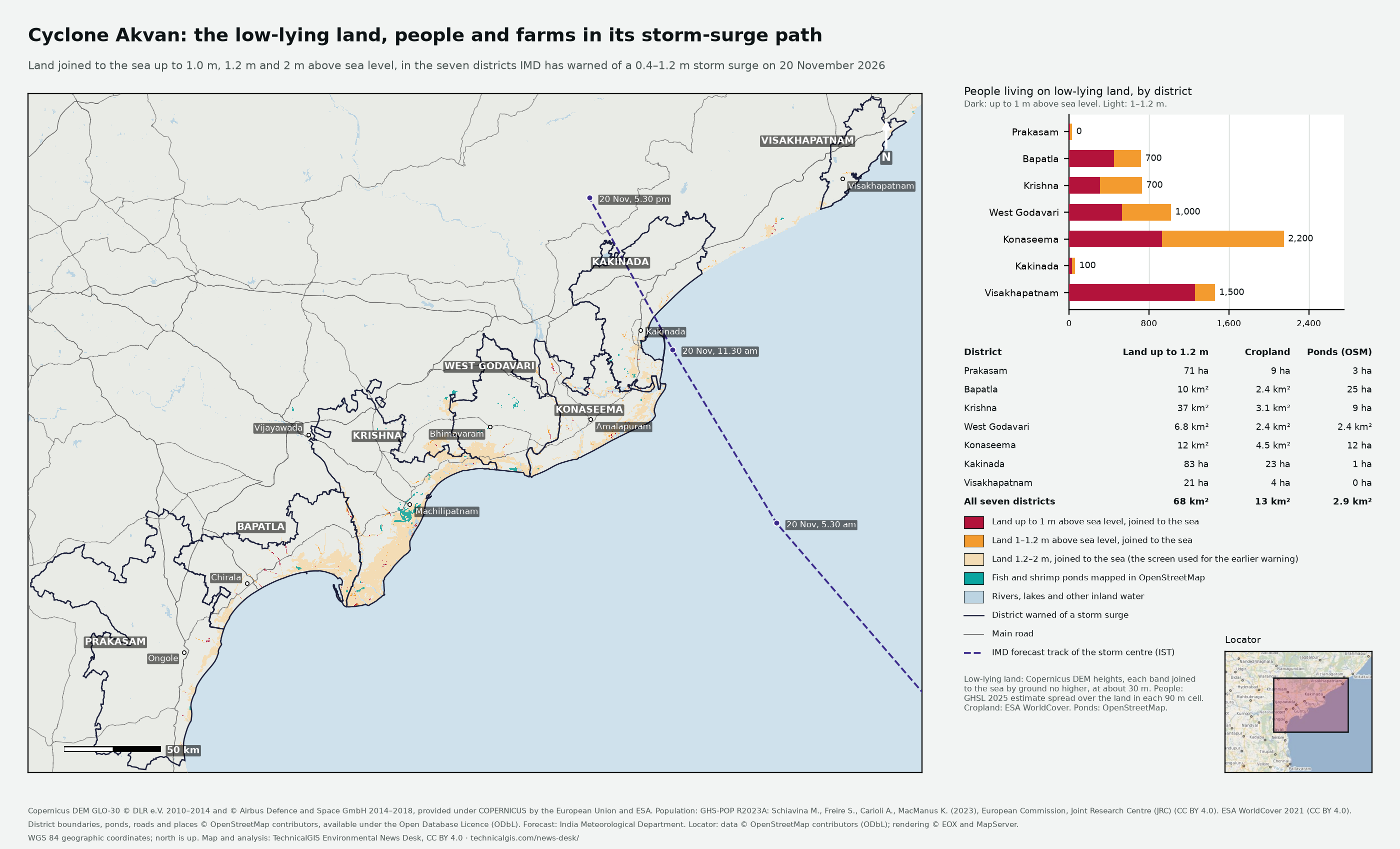
Cyclone Akvan was over the Bay of Bengal at 8.30 pm IST on Tuesday 17 November 2026, about 590 km east of Chennai and 640 km south-east of Machilipatnam, moving slowly north-north-west. The India Meteorological Department (IMD) expects it to strengthen into a severe cyclonic storm on the morning of 18 November and a very severe cyclonic storm on the evening of 19 November, then cross the Andhra Pradesh and Yanam coast between Nellore and Visakhapatnam around noon on 20 November, with winds of 120–130 km/h gusting to 145 km/h. IMD has warned of a storm surge of 0.4–1.2 m above the astronomical tide in Prakasam, Bapatla, Krishna, West Godavari, Konaseema, Kakinada and Visakhapatnam districts, highest over Bapatla, Krishna, West Godavari and Kakinada from the morning to the afternoon of 20 November.
Forecast source: IMD National Bulletin 18, issued 10.30 pm IST on 17 November 2026.
Across the seven districts, about 6,200 people live on 68 km² of land no more than 1.2 m above mean sea level that is joined to the sea. It includes 13 km² of cropland and 2.9 km² of fish and shrimp ponds mapped in OpenStreetMap. About 3,500 people live on land no more than 1 m above sea level.
For comparison with the earlier warning of a surge of up to 2 m, the same method finds about 77,000 people on 880 km² of land up to 2 m. The surge comes on top of the tide, so at high tide water can reach higher than the surge alone.
Earlier this month Cyclone Murasu left about 264 km² of candidate floodwater on this coast. Only 1% of it lies on land up to 1.2 m joined to the sea: most of Murasu's flooding was rain and river water on ground that a storm surge would not reach. Read our satellite map of Murasu's flooding.
| District | Land up to 1.2 m | People up to 1.2 m | People up to 1 m | Cropland up to 1.2 m | Ponds mapped in OpenStreetMap, up to 1.2 m | People up to 2 m (earlier screen) |
|---|---|---|---|---|---|---|
| Prakasam | 71 ha | 0 | 0 | 9 ha | 3 ha | 4,600 |
| Bapatla | 10 km² | 700 | 400 | 2.4 km² | 25 ha | 10,000 |
| Krishna | 37 km² | 700 | 300 | 3.1 km² | 9 ha | 13,000 |
| West Godavari | 6.8 km² | 1,000 | 500 | 2.4 km² | 2.4 km² | 12,000 |
| Dr B.R. Ambedkar Konaseema | 12 km² | 2,200 | 900 | 4.5 km² | 12 ha | 26,000 |
| Kakinada | 83 ha | 100 | 0 | 23 ha | 1 ha | 7,100 |
| Visakhapatnam | 21 ha | 1,500 | 1,300 | 4 ha | 0 ha | 3,600 |
| All seven districts | 68 km² | 6,200 | 3,500 | 13 km² | 2.9 km² | 77,000 |
The analysis covers the seven districts named in the IMD storm-surge warning, inside a box from 79.30° to 83.60° E and 14.95° to 18.08° N. Low-lying land in neighbouring districts is shown on the map but not counted.
What changed in revision 4: Updated for IMD's later bulletins of 17 November (National Bulletins 16 and 18). The landfall corridor moved from Nellore–Tuni to Nellore–Visakhapatnam; Visakhapatnam district was added to the storm-surge warning; the surge forecast fell from 1–2 m to 0.6–1.3 m in Bulletin 16 and 0.4–1.2 m in Bulletin 18; Kakinada joined the districts where the surge should peak; and the forecast track moved north-east. We added Visakhapatnam district, recalculated every figure for land up to 1.0 m and 1.2 m, and kept the earlier 2 m figures as context. Each height band is now joined to the sea through ground no higher than that band, so fewer people are counted up to 1 m than in revision 3 (about 3,500 rather than 6,800).
Revision 3 (2026-11-17T13:41:27Z) · Revision 4 (2026-11-17T17:54:54Z)